Western Visayas
Western Visayas
Kabisay-an Nakatundan Kanlurang Visayas | |
|---|---|
 Location in the Philippines | |
| Coordinates: 11°08′N 122°32′E / 11.13°N 122.53°E | |
| Country | |
| Island group | Visayas |
| Regional center and largest city | Iloilo City |
| Area | |
• Total | 12,750.63 km2 (4,923.05 sq mi) |
| Highest elevation | 2,117 m (6,946 ft) |
| Population (2020 census)[1] | |
• Total | 4,730,771 |
| • Density | 370/km2 (960/sq mi) |
| Time zone | UTC+8 (PST) |
| ISO 3166 code | PH-06 |
| Provinces | |
| Independent cities | |
| Component cities | |
| Municipalities | 98 |
| Barangays | 3,209 |
| Cong. districts | 10 |
| Languages | |
| GDP (2023) | ₱620.79 billion $10.55 billion[2] |
| Per capita | $2,225 (2023 est.)[2] |
| HDI | |
| HDI rank | 5th in the Philippines (2019) |
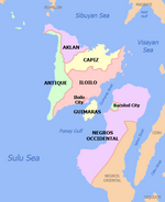
Western Visayas (Hiligaynon: Kabisay-an Nakatundan; Tagalog: Kanlurang Kabisayaan; Filipino: Kanlurang Visayas) is an administrative region in the Philippines, numerically designated as Region VI. The region comprises the islands of Panay and Guimaras. It consists of five provinces: Aklan, Antique, Capiz, and Iloilo on Panay, and the island province of Guimaras. The region also includes one highly urbanized city, Iloilo City, which is the largest city and serves as the regional center.[3]
The Hiligaynon language, native to Iloilo City, is the region's lingua franca. The region is also dominated by the native speakers of three Visayan languages: Kinaray-a, Aklanon and Capiznon. The land area of the region is 12,750.63 km2 (4,923.05 sq mi), and with a population of 4,730,771 inhabitants.
Etymology
[edit]The region's current name is in reference to its geographic position in the greater Visayas area.
History
[edit]Regions first came into existence on September 24, 1972, when the provinces of the Philippines were organized into 11 regions by Presidential Decree No. 1 as part of the Integrated Reorganization Plan by President Ferdinand Marcos Sr. The provinces of Aklan, Antique, Capiz, Iloilo (including its then-subprovince of Guimaras), and Negros Occidental were grouped together to form the Western Visayas region.
The province of Palawan was transferred to Region VI (Western Visayas) on May 23, 2005, by Executive Order 429.[4] The Department of the Interior and Local Government announced in June 2005 that the transfer had been completed.[5] However, Palaweños criticized the move, citing a lack of consultation, with most residents in Puerto Princesa City and all municipalities but one preferring to stay with Region IV-B. Consequently, Administrative Order No. 129 was issued on August 19, 2005, to address this backlash. This Order directed the abeyance of Executive Order 429 pending the approval of an implementation plan for the orderly transfer of Palawan from Region IV-B to Region VI.[6] Hence, Palawan is currently still part of Region IV-B.
By virtue of Executive Order No. 183 issued on May 29, 2015, by President Benigno Aquino III, the province of Negros Occidental and its capital, Bacolod, were both removed from Western Visayas in order to form the Negros Island Region along with Negros Oriental.[7] But later regained Negros Occidental and its capital, Bacolod City back into Western Visayas on August 9, 2017, when President Rodrigo Duterte dissolved the Negros Island Region, revoking Executive Order No. 183, s. 2015 through the signage of Executive Order No. 38, citing the reason of the lack of funds to fully establish the NIR according to Benjamin Diokno, the Secretary of Budget and Management.[8]
On June 13, 2024, the region again lost Negros Occidental and Bacolod when the Negros Island Region was reestablished under Republic Act No. 12000 signed by President Bongbong Marcos[9]
Geography
[edit]Western Visayas consists of the major island of Panay and the smaller Guimaras, as well as several outlying islands. Its land area is 12,750.63 km2 (4,923.05 sq mi), 4.25% of the country's total land area.
The region is bordered to the north by the Sibuyan Sea, northeast by the Visayan Sea, southeast by the island of Negros, south by the Iloilo Strait and Panay Gulf, and west by the Sulu Sea.
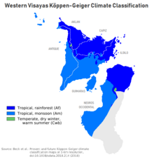
Administrative divisions
[edit]Provinces
[edit]Western Visayas consists of 5 provinces, 1 highly urbanized city, 2 component cities, 98 municipalities and 3,209 barangays.
| Province or HUC | Capital | Population (2020)[1] | Area[10] | Density | Cities | Muni. | Barangay | |||||
|---|---|---|---|---|---|---|---|---|---|---|---|---|
| km2 | sq mi | /km2 | /sq mi | |||||||||
| Aklan | Kalibo | 7.7% | 615,475 | 1,760.30 | 679.66 | 350 | 910 | 0 | 17 | 327 | ||
| Antique | San Jose de Buenavista | 7.7% | 612,974 | 2,730.67 | 1,054.32 | 220 | 570 | 0 | 18 | 590 | ||
| Capiz | Roxas | 10.1% | 804,952 | 2,594.64 | 1,001.80 | 310 | 800 | 1 | 16 | 473 | ||
| Guimaras | Jordan | 2.4% | 187,842 | 611.87 | 236.24 | 310 | 800 | 0 | 5 | 98 | ||
| Iloilo | Iloilo City | 25.8% | 2,051,899 | 4,997.64 | 1,929.60 | 410 | 1,100 | 1 | 42 | 1,721 | ||
| Iloilo City | † | — | 5.8% | 457,626 | 78.34 | 30.25 | 5,800 | 15,000 | — | — | 180 | |
| Total | 4,730,771 | 12,750.63 | 4,923.05 | 370 | 960 | 2 | 98 | 3,209 | ||||
| ||||||||||||
Governors and vice governors
[edit]| Province | Image | Governor | Political Party | Vice Governor | |
|---|---|---|---|---|---|

|
Jose Enrique Miraflores | PDP–Laban | Reynaldo Quimpo | ||

|
Rhodora Cadiao | NUP | Edgar Denosta | ||

|
Fredenil Castro | Lakas | James Magbanua | ||

|
Joaquin Carlos Rahman Nava | NUP | John Edward Gando | ||

|
Arthur Defensor Jr. | NUP | Christine Garin | ||
Cities
[edit]- † Regional center
| City | Population (2020)[1] | Area | Density | City class | Income class | Province | ||
|---|---|---|---|---|---|---|---|---|
| km2 | sq mi | /km2 | /sq mi | |||||
| † Iloilo City | 457,626 | 78.34 | 30.25 | 5,800 | 15,000 | Highly urbanized | 1st | Iloilo |
| Passi | 88,873 | 251.39 | 97.06 | 350 | 910 | Component | 4th | Iloilo |
| Roxas | 179,292 | 95.07 | 36.71 | 1,900 | 4,900 | Component | 1st | Capiz |
Demographics
[edit]| Year | Pop. | ±% p.a. |
|---|---|---|
| 1903 | 1,083,474 | — |
| 1918 | 1,347,249 | +1.46% |
| 1939 | 2,173,579 | +2.30% |
| 1948 | 2,530,517 | +1.70% |
| 1960 | 3,078,305 | +1.65% |
| 1970 | 3,618,326 | +1.63% |
| 1975 | 4,146,390 | +2.77% |
| 1980 | 4,525,615 | +1.77% |
| 1990 | 5,393,333 | +1.77% |
| 1995 | 5,776,938 | +1.30% |
| 2000 | 6,211,038 | +1.57% |
| 2007 | 6,843,643 | +1.35% |
| 2010 | 7,102,438 | +1.36% |
| 2015 | 7,536,383 | +1.14% |
| 2020 | 7,954,723 | +1.07% |
| Data in 2015 and 2020 includes Negros Occidental and Bacolod. Source: Philippine Statistics Authority[11][12] | ||
According to the 2020 census, it has a population of 4,730,771. Before Negros Occidental and Bacolod separated from the region in 2024, it was 7,954,723.
Languages
[edit]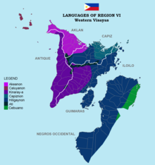
The native languages of Western Visayas are:
- Aklanon/Akeanon, spoken in Aklan and northwestern Capiz.
- Capiznon, spoken in Capiz, northeastern Iloilo, and eastern Aklan.
- Hiligaynon, spoken in Iloilo, Guimaras, Capiz, Antique, and Aklan. It is the regional lingua franca.
- Kinaray-a, spoken in Antique, southwestern half of Iloilo, Guimaras, western Capiz, and southwestern Aklan.
- Malaynon, spoken in northwestern Aklan including Boracay Island.
- Caluyanon, spoken in the Semirara Islands (Semirara, Caluya, and Sibay Islands).
Economy
[edit]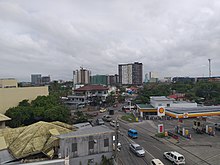
Poverty incidence of Western Visayas
10
20
30
40
2006
29.08 2009
30.80 2012
29.14 2015
24.60 2018
16.32 2021
13.80 Source: Philippine Statistics Authority[13][14][15][16][17][18][19][20] |
Western Visayas is the sixth largest economy in the Philippines, comprising three major sectors: agriculture, forestry, and fishery; services; and industry.[21] Iloilo City serves as the region's economic hub. Other major trading and commercial centers in the region include Roxas City for Capiz and the entire northern Panay. Provincial capitals such as Kalibo in Aklan, San Jose in Antique, and Jordan in Guimaras serve as the commercial centers for their respective provinces. Metro Iloilo, composed of Iloilo City and the municipalities of Oton, San Miguel, Pavia, Leganes, Santa Barbara, and Cabatuan, is the center for trading, commercial, financial, and industrial activities in the region.
Tourism
[edit]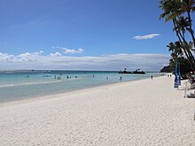
The region is known for its rich cultural heritage and natural beauty, features several key tourism highlights. Boracay Island, located in Malay, Aklan, is world-famous for its pristine white sand beaches, crystal-clear waters, and vibrant nightlife. Miag-ao Church in Miag-ao, Iloilo, a UNESCO World Heritage Site, showcases unique Baroque-Romanesque architecture and detailed designs. Iloilo City, a UNESCO Creative City of Gastronomy, is also known for its colonial-era heritage houses, churches, and buildings. The Gigantes Islands in Carles, Iloilo, are known for their white sand beaches, sandbars, limestone cliffs, and clear blue waters. Panay Church in Panay, Capiz hosts the biggest church bell in Asia. Mount Madja-as in Antique is the highest mountain in the region. Guimaras mangoes from Guimaras are known as some of the sweetest in the world. The region is also home to popular festivals such as the Dinagyang of Iloilo City and the Ati-Atihan of Kalibo, Aklan.
Transportation
[edit]Roads
[edit]
Western Visayas is interconnected by major inter-provincial roads that facilitate travel across its provinces. Iloilo City, the region's primary urban center, relies heavily on various public transportation options, including passenger jeepneys, modern Public Utility Jeepneys (modern PUJs), white metered taxis, and tricycles within city limits. In other cities and municipalities, such as Roxas City, Kalibo, and San Jose de Buenavista, tricycles are the primary mode of transport for short distances. Travel between cities and municipalities across Panay Island is typically facilitated by jeepneys, vans, and buses operated by companies like Ceres.
In March 2019, the Land Transportation Franchising and Regulatory Board (LTFRB) launched a Premium Point-to-Point Bus Service in Iloilo City, providing express bus services to airports in Cabatuan, Kalibo, and Caticlan (Boracay).
One of the major infrastructure projects proposed in the region is the Iloilo-Capiz-Aklan Expressway (ICAEx). The expressway will link two major cities and 20 municipalities across the three provinces of Iloilo, Capiz, and Aklan.[22] The Panay–Guimaras Bridge, part of the larger Panay-Guimaras-Negros Bridge project, is also well underway and set to begin construction in 2025. The Boracay Bridge, which will connect the island of Boracay to the mainland of Panay, is also being proposed.[23] Once completed, the three projects will provide land-based transportation connections to all key areas in the region.[24]
Ports
[edit]
The Port of Iloilo is the primary seaport serving the region. Other seaports include Dumangas Port in Dumangas, Iloilo, serves ro-ro and fastcraft to Negros Island and vice versa; Jordan Port in Guimaras, serves ferries from Iloilo City and vice versa; Culasi Port in Roxas, Capiz, serves ferry routes to Batangas and Caticlan and vice versa; Caticlan Port in Malay, Aklan, serves ferries to Boracay Island and vice versa; and the Port of San Jose de Buenavista in Antique, which serves ferries to Palawan and Iloilo City and vice versa.
Airports
[edit]Western Visayas is served by two international airports and three domestic airports. Iloilo International Airport, located in Cabatuan, Iloilo, serves the general area of Metro Iloilo–Guimaras as well as the entire province of Iloilo, and a gateway into the region. Kalibo International Airport serves the general area of Aklan and is one of the two airports serving Boracay, the other being the domestic Godofredo P. Ramos Airport in Caticlan, Malay, Aklan. The other domestic airports are Roxas Airport, serving the general area of Roxas City and the province of Capiz, and Evelio B. Javier Airport, serving the general area of the province of Antique.
The other airports and airstrips in the region include Semirara Airport on Semirara Island in Caluya, Antique; Sicogon Airport on Sicogon Island in Carles, Iloilo; and Guimaras Airstrip.
Rail
[edit]Proposals to re-connect again Iloilo-Roxas, Iloilo-Kalibo, Iloilo-Malay (Aklan) and Iloilo-San Jose (Antique) from Iloilo City via rail was included in the revival of the currently defunct Panay Railways network which has a station in Santa Barbara town proper.[25]
Notable people
[edit]References
[edit]- ^ a b c Census of Population (2020). "Region VI (Western Visayas)". Total Population by Province, City, Municipality and Barangay. Philippine Statistics Authority. Retrieved July 8, 2021.
- ^ a b "2021 to 2023 Gross Regional Domestic Product (GRDP)". openstat.psa.gov.ph. Philippine Statistics Authority. Retrieved April 26, 2024.
- ^ "History of Urban Growth of Iloilo City". Iloilo City Government. Archived from the original on June 30, 2012. Retrieved June 28, 2012.
- ^ President of the Philippines. "Executive order No. 429". Office of the Press Secretary. Archived from the original on July 7, 2007.
- ^ "Palawan, Puerto Princesa Transfer to Region VI" (Press release). Government of the Philippines. June 3, 2005.
- ^ President of the Philippines (August 19, 2005). "Administrative Order No. 129". Office of the Press Secretary. Archived from the original on July 13, 2006.
- ^ "Executive Order No. 183, s. 2015". Official Gazette (Philippines). May 29, 2015. Retrieved June 5, 2015.
- ^ "Duterte dissolves Negros Island Region". Rappler. August 9, 2017. Retrieved August 10, 2017.
- ^ "Marcos signs law creating Negros Island Region". ABS-CBN. June 13, 2024. Retrieved June 13, 2024.
- ^ "PSGC Interactive; List of Provinces". Philippine Statistics Authority. Archived from the original on July 11, 2016.
- ^ Census of Population (2015). "Region VI (Western Visayas)". Total Population by Province, City, Municipality and Barangay. Philippine Statistics Authority. Retrieved June 20, 2016.
- ^ "Population and Annual Growth Rates for The Philippines and Its Regions, Provinces, and Highly Urbanized Cities" (PDF). 2010 Census and Housing Population. Philippine Statistics Authority. Archived from the original (PDF) on September 28, 2013. Retrieved August 9, 2013.
- ^ "Poverty incidence (PI):". Philippine Statistics Authority. Retrieved December 28, 2020.
- ^ "Estimation of Local Poverty in the Philippines" (PDF). Philippine Statistics Authority. November 29, 2005.
- ^ "2009 Official Poverty Statistics of the Philippines" (PDF). Philippine Statistics Authority. February 8, 2011.
- ^ "Annual Per Capita Poverty Threshold, Poverty Incidence and Magnitude of Poor Population, by Region and Province: 1991, 2006, 2009, 2012 and 2015". Philippine Statistics Authority. August 27, 2016.
- ^ "Annual Per Capita Poverty Threshold, Poverty Incidence and Magnitude of Poor Population, by Region and Province: 1991, 2006, 2009, 2012 and 2015". Philippine Statistics Authority. August 27, 2016.
- ^ "Annual Per Capita Poverty Threshold, Poverty Incidence and Magnitude of Poor Population, by Region and Province: 1991, 2006, 2009, 2012 and 2015". Philippine Statistics Authority. August 27, 2016.
- ^ "Updated Annual Per Capita Poverty Threshold, Poverty Incidence and Magnitude of Poor Population with Measures of Precision, by Region and Province: 2015 and 2018". Philippine Statistics Authority. June 4, 2020.
- ^ "2021 Full Year Official Poverty Statistics of the Philippines" (PDF). Philippine Statistics Authority. August 15, 2022. Retrieved April 28, 2024.
- ^ "Tables | Philippine Statistics Authority | Republic of the Philippines". psa.gov.ph. Retrieved June 14, 2024.
- ^ Sornito, Ime (May 29, 2024). "DPWH reviews proposal for Iloilo-Capiz-Aklan Expressway". Panay News. Retrieved August 6, 2024.
- ^ Guardian, Daily (August 2, 2024). "Boracay Bridge to get PPP funding in 2025 budget". Daily Guardian. Retrieved August 12, 2024.
- ^ "Defensor Expects Dev't Projects For Iloilo In PBBM's 3rd Sona". www.iloilo.gov.ph. Retrieved August 6, 2024.
- ^ Salvilla, Rex S. (July 28, 2006). "Anything Under the Sun: Panay Railways". The News Today. TNT Publishing, Inc. Retrieved June 12, 2008.
External links
[edit] Media related to Western Visayas at Wikimedia Commons
 Western Visayas travel guide from Wikivoyage
 Geographic data related to Western Visayas at OpenStreetMap

